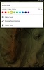


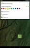
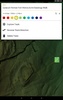
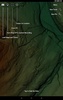
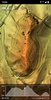


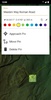
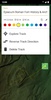
Explore landscapes with precision using planlauf/TERRAIN, an innovative mobile application designed to integrate with its desktop counterpart for creating and displaying detailed 2D and 3D LiDAR maps. Enhance your hiking or exploration activities with the convenience of GPS functionality, and for select regions, even purchase 2D LiDAR maps directly through the app. Immerse yourself in topographical clarity and elevate your outdoor experiences with this cutting-edge navigation tool.
The app integrates seamlessly with your mobile device, bringing high-resolution mapping capabilities to your fingertips. Whether you're trekking through an unfamiliar territory or enjoying a leisurely nature walk, you can access accurate topographical data and 3D maps that make navigation simple and engaging. For added convenience, certain areas allow users to acquire additional maps from within the interface, ensuring that the most detailed information is always at hand.
Take the leap into enhanced outdoor exploration. With planlauf/TERRAIN, transforming your adventures has never been easier. The use of LiDAR technology allows for an enriched view that goes far beyond the limitations of traditional mapping solutions. Embrace the future of terrain navigation and discovery today.
Requirements (Latest version)
- Android 5.1 or higher required

Comments
There are no opinions about planlauf/TERRAIN yet. Be the first! Comment